Meghalaya is a state in north-eastern India. The word "Meghalaya" literally means the Abode of Clouds in Sanskrit and other Indic languages. Meghalaya is a hilly strip in the eastern part of the country. The state is bounded on the north by Assam and by Bangladesh on the south. The capital is Shillong also known as the Scotland of the East, which has a population of 260,000. Meghalaya currently has 7 districts. These are: East Garo Hills, East Khasi Hills, Jaintia Hills, Ri-Bhoi, South Garo Hills, West Garo Hills and West Khasi Hills.
Meghalaya is one of the most picturesque states of India Umiam Lake
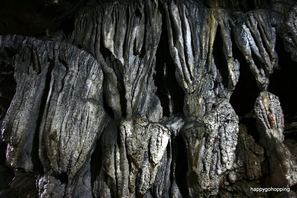
Meghalaya has an estimated 500 natural limestone and sandstone caves spread over the entire state including most of the longest and deepest caves in the sub-continent. Krem Liat Prah is the longest cave and Synrang Pamiang is the deepest cave, both located in the Jaintia Hills. Cavers from United Kingdom , Germany, Austria , Ireland and the US have been visiting Meghalaya for over a decade exploring these caves. Not many of these have however been developed or promoted adequately for major tourist destinations.
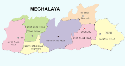
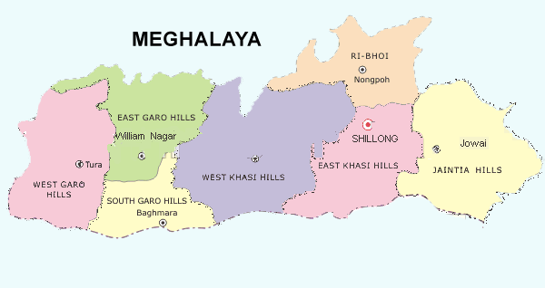
District map of Meghalaya


How to Reach Meghalaya
By Air: The state has no airport. Guwahati is the nearest airport from Shillong (128Kms). But a helicopter service is operated by Guwahati and Tura for Shillong.
By Rail: The state has no railway station. Guwahati is the closest railway station.
By Road: The state has a good Road Network which encompasses the state conveniently. NH 40 connects the state with Guwahati and other cities of the country.
Entry Formalities: Foreign tourists need a valid visa which can be further extended and Indian tourists need not obtain any permit for entry.
Best way to travel: Hire a cab from Guwahati for to and fro journey. Cab hiring charges are around Rs.25000 for total journey (for 7-8 days). It’s recommended that you travel in a group and take out a minimum of 7-8 days for this journey.
Best time to visit:
Visit Meghalaya any time of the year except the rainy season, which is June to September. This is, after all, one of the wettest places on earth!
Climate:
In summer, ranges from 15°C to 25°C; in winter, it is much colder, with temperature ranging between 4°C and 16°C. The hills are also often covered by fog during this season.
Things required:
Warm woollen clothes, mosquito repellent, candle and match-box (since there’s frequent power failure throughout Meghalaya) and an umbrella/rain-coat.
Accomodation:
There are lot of Government Guest Houses available at Shillong, Mawlynnong village, Cherrapunji(Sohra) and Jowai. The Government Guest Houses and Hotels information can be accessed from http://megtourism.gov.in/accommodation.html.
Itinerary:
Meghalaya can be visited using different circuits. We followed the following circuits during our travel.
CIRCUIT 1: Guwahati - Umiam Lake – Shillong – Dawki - Mawlynnong Village
This circuit can be covered in two days. You arrive at Guwahati in the morning on the first day and start for Shillong and night stay at Shillong. Next Day start for Mawlynnong Village and night stay at Mawlynnong Village
Location: Ri Bhoi District on the Guwahati-Shillong National Highway
More popularly known as Barapani, this is the biggest artificial lake in the State. Surrounded by Sylvan Hills and wrapped in the beauty of an assortment of green Khasi-pines and the azure blue skies is the majestic Umiam lake. The lake situated just 15 km from Shillong on the Guwahati-Shillong National Highway
Developed upon the reservoir of the Umiam Hydro Electric Project, the Water Sports Complex provides a choice of row-boats, paddle-boats, cruise boats, sailing boats, water scooters and speed boats. This is a very popular place for picnic, fishing and watersports. M.T.D.C. had started operating water-sports in the area. Also the Orchid Lake
Adjacent to the resort is the Lum Nehru Park

Umiam Lake
ShillongLocation: East Khasi Hills District
The capital city of the State as well as the District headquarter of East Khasi Hills District. The name Shillong is derived from U-Shyllong, a powerful deity and is situated at an altitude of 1,491m above sea level. This beautiful city is 103kms. from Guwahati, the nearest air and train link. The presence of many well reputed educational institutions, many of them established by various missionary groups make Shillong the hub of education for the entire north-east.
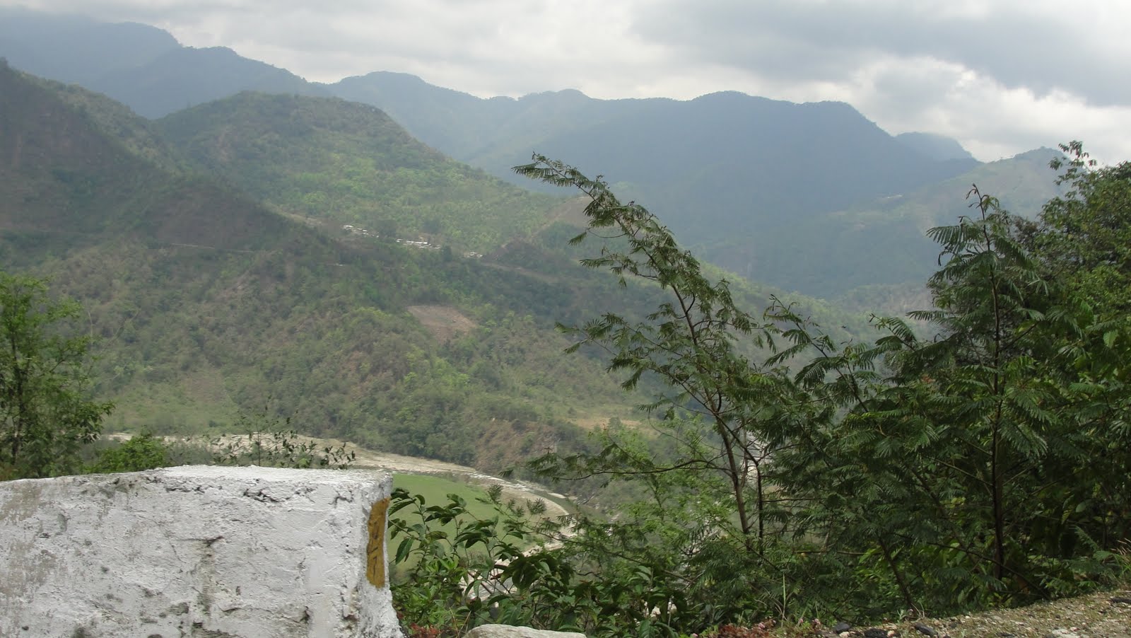
Dawki
Location: Jaintia Hills District
Travelling from Shillong to the International trade route border town of Dawki Bangladesh

Scenic beauty around Dawki

Indo-Bangladesh Border
Location: East Khasi Hills District
Mawlynnong nestled in the pristine hill state of Meghalaya, is along the Indo-Bangla border. This cute and colourful little village is known for its cleanliness. The main occupation of the villagers is agriculture. They mostly grow betel nut. About 82 households live in Mawlynnong. Keeping the surrounding environment clean is an age old tradition.

Tree House


Living root bridge
CIRCUIT 2: Mawlynnong - Cherrapunjee – Shillong
Most of the people cover this circuit in one day and visit Cherrapunjee and return to Shillong the same day. However it make sense to stay one night at Cherrapunjee and visit the caves, water falls and Laitkynsew double decker root bridge. We recommend to start early from Mawlynnong for Cherrapunjee and visit the water falls and caves the same day. Next day visit the Laitkynsew double decker root bridge which is a one day activity and a life time experience .
Sohra (Cherrapunjee)
Location: East Khasi Hills District, Sohra
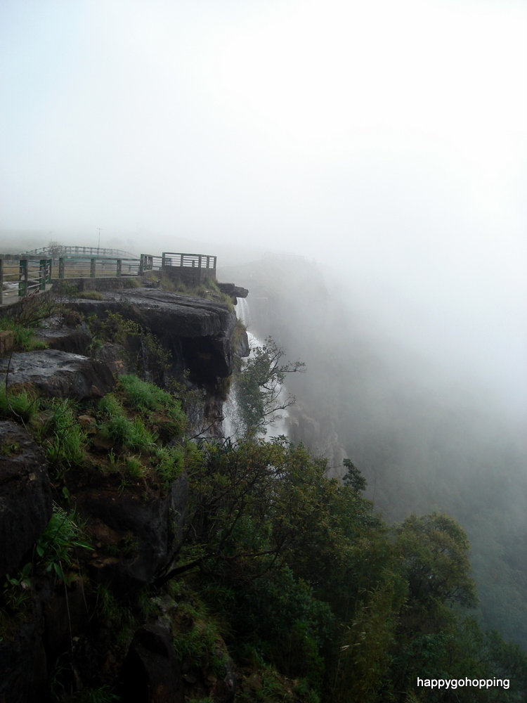
Sohra, previously known as Cherrapunjee, a Sub-Division in the East Khasi Hills District of Meghalaya, is set upon a plateau on the southern slopes of the state. Sohra is dotted with waterfalls cascading over deep gorges. The swift flowing rivers and streams flow in a southernly direction to the plains.
Sohra is 56 kms from Shillong and is literally the highest point of any visit in Meghalaya. One of those ultimate eco-friendly destinations, a place renowned all over the world for having the privilege of receiving the highest rainfall in the world. Set against the backdrop of breath-taking landscape, it is a place to discover the Indian summer monsoons. A unique annual meterological phenomena directly influenced by the south west monsoon and the north east winds. The heavy monsoon rains over these mountains undoubtedly creates in Sohra one of the rarest bio-diverse vegetations in the world. Truly a beautiful corner in north-east India
The temperature starts warming by the third week of May and continues right to the end of September and sometimes gets extended well into the middle of October. The average rainfall is 12,000 mm a year, with the maximum rainfall occuring over the southern slopes of the Khasi Hills in Sohra. The highest recorded total annual rainfall was 24,555 mm in 1974. The maximum for a single day was recorded in 1876 in Sohra, when 1,040 mm fell in 24 hours. Sohra also holds the World Record for a month's rainfall when 9,300 mm fell in July 1861.
The old Cherra or Sohrarim was the original Cherra village but with the coming of the British who set up their headquarters further south, the village came to be known as 'Sohra' or present day Cherrapunjee. It was here that the British realised the enormity and intensity of the rainfall and set up a meterological office for measuring the rain.
Sohra was declared by the British to be the capital of Assam


Location: East Khasi Hills District, Sohra
A few kms from Umtynagar, as one takes the right turn from the road junction, one comes across a beautiful bridge known to the locals as the Duwan Singh Syiem Bridge

Location: East Khasi Hills District, Sohra
Located on the way to the world famous ‘Dainthlen Falls’ and about 3 kms before reaching Sohra town is Sa -I - Mika Park, a one stop tourist destination. Set amidst 69 acres of pristine surroundings, Sa -I - Mika offers not only accommodation but a host of activities that is caters to people from all ages and walks of life. At present there are four double bedded rooms with all modern amenities and two traditional cottages. On offer are well appointed rooms, hot and cold running water, room service priced at Rs.1200/- and Rs.1500/- per night. There is also a 200 capacity conference hall which is suitable for hosting cooperate and departmental events, seminars, workshops and concerts. On request, the management can also arrange to organise barbecues, bonfires, tour guides, traditional Khasi dance and local cuisine and drink.
The park has the distinct advantage of being located close to the waterfalls and one can arrange treks and tours to these places, as well as the caves and other areas of tourist interest. Since the management is closely associated with the community, one can also opt for a homestay in one of the villages, to experience life with a typical Khasi family.
Location: East Khasi Hills District, Sohra
Just before reaching Sohra, a road to the right, leads one to the falls which is 5 kms away. The waterfall derives its name from a Thlen or a snake of gigantic size which dwelt in a cave. Legend has it that the people destroyed the snake in order to rid themselves of its reign of terror. Adjacent to the very spot where the Thlen was slaughtered lies the Dain-thlen Waterfalls. Natural rock carvings of the episode draw visitors to see the image of the Thlen, the symbol of greed, corruption and evil.

Location: East Khasi Hills District, Sohra
A hauntingly beautiful waterfall, cascading down from the top of the gorge to the mystic deep green pool below, reminding one of the tragic legend associated with it, of a grief stricken mother who plunged to her death, unable to overcome her sorrow over the murder of her daughter by her husband.


Location: East Khasi Hills District, Sohra
Access to the cave is via the river, which lies to the south east of the Cement Factory. The entrance is about 10 ft. above water level. A single entrance leads to a double passageway, where the upper portion in certain areas have caved in due to the intensive quarrying of limestone above the cave. The river enters the cave and forms pools of water within the cave. This cave stretches for about 4,500 meters but is marred by pollution entering the cave from the cement factory. Locally known as Krem Mawmluh, it is one of the longest caves in the Indian subcontinent.


Location: East Khasi Hills District, Sohra
A large "Eco Park Eco Park offers breathtaking view of distant Sylhet Plains of neighbouring Bangladesh

Location: East Khasi Hills District, Sohra
Managed and well maintained by the State Forest Department, this park on Mawsmai - Shella Road Bangladesh
Ka Khoh Ramhah
Location: East Khasi Hills District, Sohra
Also known as Motrop, is an imposing single rock formation in the shape of a giant cone. According to folklore, this was the fossilized cone shaped basket of an evil giant. It lies in close proximity to two other very similar rocks standing like a pair of giant sentinels. During the heavy monsoons, water flows between the two rocks and the cascading waterfall presents a breathtaking sight. The place attracts a lot of visitors throughout the year and is an idyllic picnic spot.
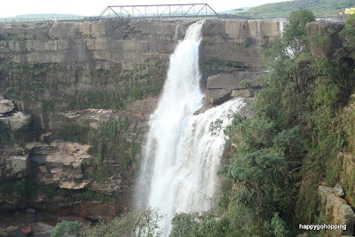
Location: East Khasi Hills District, Sohra
The highest waterfall in Meghalaya, it cascades down in three stages from the top of the hill and overlooks the Thangkharang Park
Laitkynsew
Location: East Khasi Hills District
15 Kms further from Sohra (Cherrapunjee) there is a holiday resort run by a private party. The resort offers visitors treks around the picturesque hills, spring bath, the thrills of caving and many other forms of excitement. Close to the resort there is the living root bridge across a torrential stream, that any visitor would love to see.
In the adjacent village of Nongriat
Trek to the Living Root Bridge (Ummunoi) –
The trek takes around nine hours involving a walk downhill 2,500 ft and up. Total distance of 25 km (approx) of which 10 km is by a beautiful mountain skirting road commanding a beautiful view of the valley and through three colourful Khasi villages — Nongraite, Nongthymmai and Mynteng. Trek is open throughout the year. This trek starts from the Resort premises and goes down hill through village Sohsahrat. The steps are relatively steeper in two short stretches. Half the distance is covered by steps going down hill. Then there is a jungle path going along the sides of the hill leading to the Living Root Bridge with a few steps after short stretches of sloping foot path. Moss thrives on these sandstone steps during the monsoon and makes them slippery. However, the steps can be negotiated easily with little care by locking the hind of your feet in the depressions between stones in the steps. The path thru’ the jungle and bay leaf gardens is quite interesting. As you near the bridge you hear the sound of water flowing by the stream. After admiring the Living Root Bridge and taking snaps, get down into the stream and take a refreshing bath in the stream. En-route you get to see snails, millipedes, butterflies and spiders in their webs. After seeing the bridge you move ahead to a naturally formed Dolomite archway. Notice how the villagers tap the water from the stream by bamboo pipes running long distances to drip irrigate the betel leaf creepers during the dry season in winter.
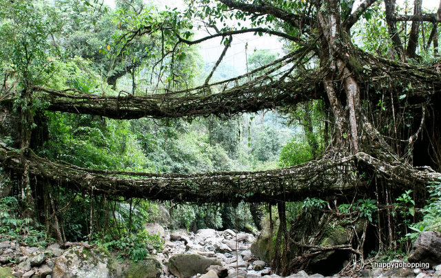
Double-decker living root bridge
Across the Ummnoi river:
Swimming - Beyond the bridge, after a walk for another 2 km to reach Mawsaw Steel Rope Bridge, one can access the famous natural swimming pools. The larger pool is deep for expert swimmer. These pools are very rough during the monsoon seasons and one is not allowed to swim. The flowing water is so crystal clear and transparent that any avid swimmer can not resist the temptation to swim. The flowing water is warmed by sunrays and the heat radiated by the huge boulders that they flow through. These pools are reached by treks down the hill.

Swimming - Beyond the bridge, after a walk for another 2 km to reach Mawsaw Steel Rope Bridge, one can access the famous natural swimming pools. The larger pool is deep for expert swimmer. These pools are very rough during the monsoon seasons and one is not allowed to swim. The flowing water is so crystal clear and transparent that any avid swimmer can not resist the temptation to swim. The flowing water is warmed by sunrays and the heat radiated by the huge boulders that they flow through. These pools are reached by treks down the hill.

CIRCUIT 3: Cherrapunjee - Shillong – Jowai
This circuit can be covered in two days. Start from Shillong and visit the Nartiang Monoliths
On the same day and night stay at Jowai. Next day visit the stone bridge, pitcher plant, water falls and lakes.
Jowai
Location: Jaintia Hills District
64 kms. from Shillong is the administrative headquarters of Jaintia Hills as well as the commercial centre. It is situated along side the Myntdu river which encircles two thirds of this over expanding township.
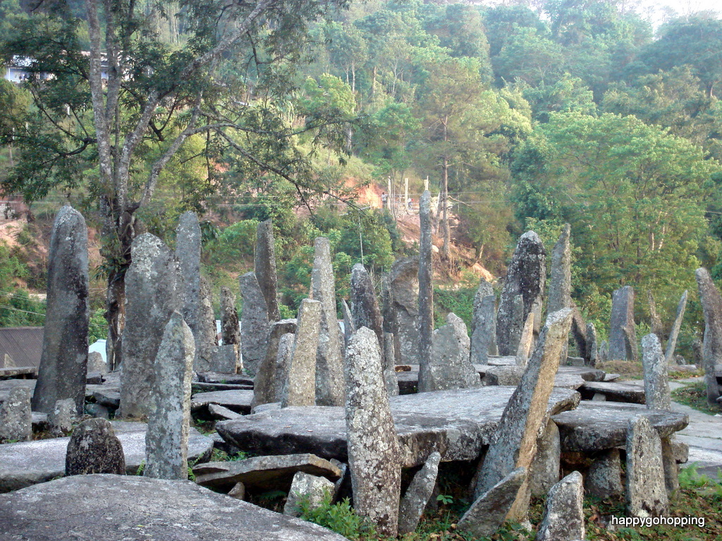
Nartiang Monoliths
Location: Jaintia Hills District
Monoliths exist throughout the length and breadth of the Khasi and Jaintia Hills. However, the biggest collection of monoliths or Megalithic stones in one single area is to be found north of the Nartiang market. These consists of Menhirs (Upright stones) Moo Shynrang and Dolmens (flat stones in the horizontal position) locally known as Moo Kynthai. Within the perimetre of these Megalithic collection stands the tallest Menhir erected by U Mar Phalyngki a trusted lieutenant of the Jaintia King to commemorate his victory in battle. Other monoliths were erected by U Mar Phalyngki, U Luh Lyngskor Lamare and various clans of Nartiang village between 1500A.D.and l835A.D.
Location: Jaintia Hills District
8 k.m.. from Jowai on National highway - 44 is a man made lake at Thadlaskein fed by a Perennial spring. According to tradition, one Chieftain Sajar Nangli had an irreconcilable difference with the King of Jaintiapur. Not wanting to be blamed for an inevitable bloodbath he decided to flee from the Kingdom with his followers. Before his departure, however, they dug the present day lake with the ends of bows as a memorial. The lake is revered by the people of Raid Mukhla who continue to offer sacrifices near the Lake . A popular picnic spot for locals.
Location: Jaintia Hills District
16 kms. from Jowai on the Jowai Muktapur road to Dawki lies Thlu Muwi. This stone bridge built by U Mar Phalyngki and U Luh Lamare under the orders of the Jaintia King. Because of the rise of the Muwistream during the monsoon a bridge was required to be built for the King's journey from Jaintiapur to Nartiang. The bridge consists of huge well hewn granite stone slabs perched on equally similar pillars. Beside the stone bridge is also the Muwi Waterfalls.

Location: Jaintia Hills District
Krang Suri is one of the most beautiful waterfalls in the District. It is located in the Amlarem Civil Sub Division. To transform the place into a tourists destination the District Administration has initiated steps to construct Chisseled and graveled footpaths and view points to enable visitors to better appreciate the beauty of the waterfall and its surroundings. The footpaths are hewn from the natural multi colored stones available in the area, no cement has been used and stones have been placed symmetrically to enhance the aesthetic appeal of the area.
Location: Jaintia Hills District
Located at Jarain, in Amlarem subdivision of War-Jaintia region amid the natural habitat of the carnivorous pitcher plant -- Nepenthenes Khasiana spreads over an area of 50,000 square metres. A pretty lake sits placidly amid gravelled footpaths, arch bridges, pitcher plant garden and green house -interpretation centre. The railings of the boat-house are styled on the pitcher plant. A pitcher plant replica in the middle of the lake doubles up as a fountain -- the setting is perfect for a leisurely boat ride. There are paddle-boats to engage visitors as they soak in the greenery of the low lying hillocks around. Four boats have been provided and the lake is attracting a lot of visitors from far and near.


Pitcher plant
Location: Jaintia Hills District