Popularly known as "Hermit Kingdom", Ladakh is a mysterious land of snow carved peaks, tranparent lakes, barren terrain and shrouded in myth and legend. Ladakh is often referred to as the "Little Tibet", or the "Last Shangri-La".
A high altitude desert in the state of Jammu and Kashmir (India) , Ladakh is bounded by the Karakoram in the north and the great Himalayas in the south. It is one of the most sparsely populated regions in India with a blend of many different races, predominantly the Tibetans, Monks and the Dards. Ladakh, a part of Jammu & Kashmir state in north India consists of two districts Leh and Kargil. Leh district comprises of Leh town and 112 inhabited villages and one un-inhabited village.
Ladakh at a glance
How to reach: By air/ by road
By Air:
Planes fly year round, and are the only option in the winter. Book early and give yourself at least a few days of flexibility as flights are often delayed due to weather conditions. Air India, Jet Airways and Kingfisher Red have daily flights from Delhi. Air India Flights are also available from Srinagar.
Travelling by plane has its own charm. One gets to see the magnificent and breath-taking view of Ladakh while flying over it.The take-off and landing are also a unique experience in themselves.
Ladakh from flight
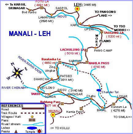
There are two roads to Leh, one from Manali in Himachal Pradesh in the south, and one from Srinagar in the west. Both routes are equally spectacular in different ways, and both are time consuming with winding, narrow roads, and numerous military checkpoints. Leh is at a distance of 434 Kms from Srinagar and 473 Kms from Manali.
Srinagar->Leh (covering a distance of 434 km/270 mi)
§ The road from Srinagar runs at a lower altitude, and thereby reduces the risk and severity of altitude sickness.
§ It is also open longer, normally from the beginning of June to October and follows the traditional trade route between Ladakh and Kashmir, which passes through many picturesque villages and farmlands.
§ It passes through areas of higher risk of militant troubles.
§ It takes two long days, with an overnight stop in Kargil.
Manali->Leh (covering a distance of 473 km/294 mi)
§ Route more commonly taken by tourists.
§ It takes two days, normally with an overnight stop either in Kyelong (alt. 3096) or in tent accommodation in Sarchu (4253) or Pang (4500).
§ Making the first stop in Keylong drastically reduces the risk of altitude sickness (AMS).
§ It traverses one of the highest road passes in the world and is surrounded by wild rugged mountains.
§ The scenery is fantastic.
§ It is definitely not for the faint hearted.
§ Reliable access is limited from mid-June to end-September, as it is blocked by snow for rest of the year.
Options to travel by road from Manali/Srinagar: a Himachal Tourism bus to Leh or a Jeep or a hired motorbike can be taken from Manali. From Srinagar also one can go by bus or by hiring a cab/jeep.
Road route from Manali to Leh
Some people also travel one way from Delhi-Manali-Leh and return via Leh-Srinagar-Delhi way or vice-versa.
The Distance between Delhi and Srinagar - 850 km
The Distance between Delhi and Manali - 521 km
How to plan the trip: There are tour packages available from various tour site, but we chose to plan our own trip so that we can explore more and according to our convenience. It is essential to first decide whether you plan to go by air or by road and in what season you’d like to go ; in summer /winter season. If you are planning by road then you first need to confirm that the roads of the route you chose are open.
Best time to make the trip: May-September
Worst time to make the trip: November-March
Climate: Summers are the ideal time to go to Leh as the skies are clear and offer panoramic views of the mountains. The temperature is cool and can go up to 33°C. The weather is extremely cold and harsh during winters, thus causing frost bites. Due to the rarefied air the effect of the sun during the winter months is much harsher and as a result can cause sun burns. But if one is interested in winter sports they can always choose to go in winters.
Care should be taken while travelling in winters: Both Manali and Kashmir roads are closed in February month and you will not be able to go by road this time and the only way to visit Ladakh is through by air. For Nubra , first you can fly to Leh and then take a taxi or bus from Leh to Nubra. In case of heavy snowfall on Khardung-La, the roads get closed for a few days. For Pangong , it depends on the snowfall at Chang-La.
Things required: Due to the unpredictable nature of the climate, tourists are advised to carry windcheaters, woollen clothing, thick socks, gloves, scarves, a hat or woollen cap, sturdy boots or walking shoes and lip balm. Carrying goggles with UV protection is must and a good sunscreen lotion of SPF(Sun Protection Factor) 30 or higher.
Health Advisory: Since Ladakh is at high altitude with low level of atmospheric oxygen, tourists may tend to suffer from acute mountain sickness (AMS). The most common symptoms of acute mountain sickness are headache, disturbed sleep, loss of appetite, nausea, coughing, irregular breathing, breathlessness, lassitude and lack of concentration. If you are reaching Leh by air, it is important to take complete rest for the first 24 hours after arrival. Any kind of physical exertion is to be avoided. Smoking and drinking should also be avoided. Drink lots of water to keep you hydrated. One can always go to the Government hospital at Leh, which is fully equipped and staffed with a team of specialists to take care of any eventuality. After the first couple of days most healthy people have adapted and will be fine.
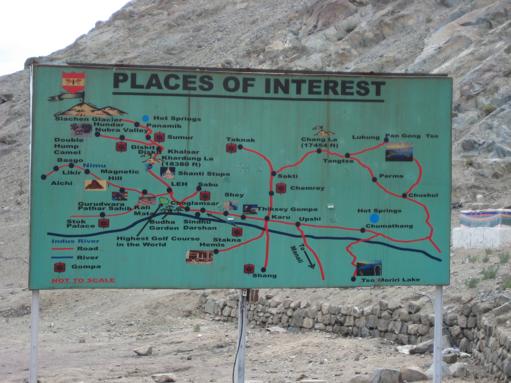
There are two most visited circuits Nubra Vally and Pangong lake. The route to both the circuits is as given in the below map.
Near entrance of Leh
Leh – Khardung La – Khalsar – Diskit – Hunder – Diskit – Sumur – Panamik
You need to hire a taxi that will take you to Nubra valley via Khardong La. This is the highest motor able road in the world (18380 ft.). If you want to make a short trip then you can go from Leh to Khardung La pass and return to Leh on the same day. However many people do decide to go to Nubra Valley, which is highly recommended. At least couple of days are needed for such an excursion, with a night stop at Diskit, Hunder or Panamik. Nubra Valley is popularly known as Ldumra or the valley of flowers. It is situated in the north of Ladakh between the Karakoram and Ladakh ranges of the Himalayas. The average altitude of the valley is 10,000 Ft. above sea level. The Shayok and Siachen Rivers drain Nubra. The villages look pretty with greenery, willow & poplar trees. The distance between Leh and Diskit (Nubra valley) is around 118kms. Leh – Khardung La (around 40 kms): “Khardung La, 18380ft is the Highest Motor able Road in the world”. For those out of breath, there is a café at the summit, where one can have a much needed cup of tea/coffee along with some snacks.
Khardung La
Khardung La – Khalsar (58 kms): After break get ready for a bumpy ride/drive till North Pallu (one needs to submit permits here as well). Khalsar – Diskit (20 kms): Few kms down the road from Khalsar the road bifurcates into two, road on the left leading to Diskit while the road on the right goes to Panamik. There are phone facilities available, hotels and guest houses available at Diskit and many people choose to stay here.
Diskit Gompa: This ancient Gompa, built in 1420AD, is perched on top of a hill overlooking town of Diskit. Access to Gompa is via a half an hour trek through a two meter wide steep path; however the breathtaking panoramic views and the Gompa are more than the effort taken. The main attraction of the Gompa is the main Deity, which holds in its hand the mummified human forearm and head, which is believed to be of a Mongol warrior.
Diskit – Hunder (8 kms): 8 kms down the road from Diskit is the village of Hunder, set amidst fields of rye and barley and surrounded by fruit orchards and sand dunes. For the people who yearn to see the moonscape scenery of Ladakh, Hunder is a welcome break. One can also enjoy the "two Hump Camel Safari" in the sand dunes between Deskit and Hunder Village.
Bacterian camel safari at Hundur
Hundur sand dunes
Hundur – Sumur (40 kms): After returning 20 odd kms you should be back at the bifurcation from where you had taken the diversion to Diskit. Now you need to take the other route going towards Sumur and Panamik. The 20km drive from here to Sumur is scenic, with the views changing every few kms. Sumur’s main attraction is the 150 year old Samstening Gompa and apart from that the village itself is an oasis in the middle of a desert. Sumur – Panamik (20 kms): 20 kms down the road from Sumur is the village of Panamik, famous for 250 year old Ensa Gompa and hot water springs. This is also the last point where tourists are allowed.
Nubra river
Restricted Area: Nubra Valley is a restricted area and you need permits to visit it. Permits are easily obtainable from the DC’s office in Leh and can be procured by either submitting the application yourself or through a travel agent. The permits are issued for a maximum period of three weeks, in case you are visiting other restricted areas like Tso Moriri and Pangong Tso you need to mention them in the permit as well. Make at least 4 photocopies of the permit per region, since you would need to submit them at various check posts.
Leh - Karu - Chang-la- Durbuk - Tangse- Luckung- Spangmik and return.
Though Leh – Pangong Tso (around 160km one way) excursion is a day’s trip by returning at night fall yet a 2-3 days trip is highly recommended otherwise it would leave very less time for the magnificent lake. The lake is 130 km long and 5 km at its widest point with half of it running to the other side of the Indo-China border.
Leh – Karu (45 kms): It’s a less than an hour’s journey from Leh to Karu if you start off early in the morning after breakfast and start driving/riding on Leh – Manali highway. The journey is fast paced as the road is in good condition.
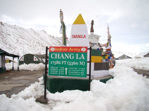
Karu – Chang La (35 kms): A left turn from Karu would take you to the village Shakti, roads are mostly straight till you cross Shakti and a few kilometer thereafter the real ascent for Chang La starts. For most part ascent is steep and roads are in good condition except the final few kms of the ascent to Chang La when the road conditions start to deteriorate and steepness increases, making reaching the summit of Chang La more challenging and memorable.
Chang La is the steepest of the passes encounterd in Ladakh (barring Marsimik La) and due to bad roads at the final ascent it is also the toughest. No wonder it is called "The Mighty Chang La" !!
At 17,800ft it is also the second highest motorable pass in Ladakh. Once you reach the summit, you will be greeted by the Indian Army troops who are stationed here to acclimatize to high altitude, before they are posted in world’s highest battlefield, Siachen. There is a temple on top of Chang La pass, called Chang La Baba ka Mandir, as well as a cabin built by the army where you can warm up yourself and have free tea while chatting with the soldiers.
Chang La – Tanksey (58 kms): After a few minutes rest, its time to begin the descent from Chang La, road is in bad condition for few kilometers, beyond which superbly laid tarmac coupled with beautiful scenery awaits you.
Your next big break will be at Tanksey a.k.a. Tangste; Tanksey is a big town with few shops, hotels and an internet café. It is a good idea to have your lunch here or in case you have arrived late in the evening, then spend the night here instead of continuing to Lukung or Spangmik where finding accommodation in peak season can be an issue.
Tanksey – Spangmik (Pangong Tso) (32 kms): For most part, journey beyond Tanksey is through fantastically laid tarmac and views. Don’t indulge in over speeding, since there are quite a few water passages built in the middle of the road, which essentially mean 8-10 feet long depression in the middle of the road without any warnings!
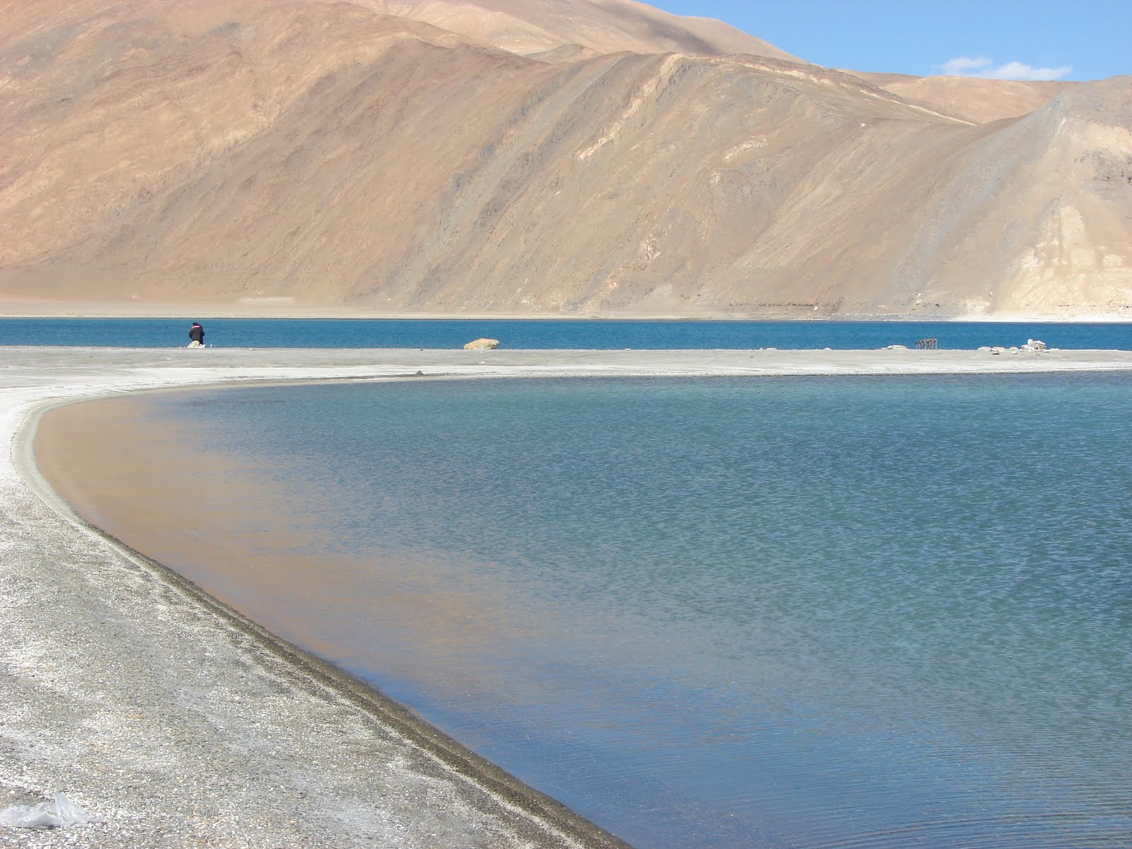
Pangong Tso Lake
As you approach the lake, the sheer size of it starts becoming more apparent as you finally reach its shores. On the banks of the lake is a military camp and also Lukung which is a collection of tents and newly built Eco Huts.
Eco hut
Accomodation on the bank of Pangong Tso lake
From here you can carry on, on the road that turns in to sand and rock filled dirt track. Spangmik, the farthest point to which we are permitted, is only some seven km along the southern shore from the head of the lake, but it affords spectacular views of the mountains of the Changchenmo range to the north, their reflections shimmering in the ever-changing blues and greens of the lake's brackish waters. Above Spangmik are the glaciers and snowcapped peaks of the Pangong range.
Around Leh
§ Leh Palace: The former Palace of the King of Ladakh. The most noticeable building in Leh, was modelled on the Potala Palace in Lhasa, Tibet. The palace was built in the 17th century, and now undergoing restoration. There's not much to see on the inside, but there are good views outside.
§ Shanti Stupa: The Shanti Stupa is located on ridge about 1km from Leh through the tourist village of Changspa. It can be reached quite easily from the Fort Road. The Stupa was constructed by a Japanese Buddhist organization, known as 'The Japanese for World Peace'. The aim behind the construction of the stupa was to commemorate 2500 years of Buddhism and to promote World Peace. His Holiness, the Dalai Lama inaugurated the Shanti Stupa in the year 1985. A magnificent white-domed structure, the Shanti Stupa of Leh - Ladakh offers spectacular views of the sunrise and sunset. The stupa looks best at night, when it is beautifully illuminated with glittering lights.
Shanti Stupa
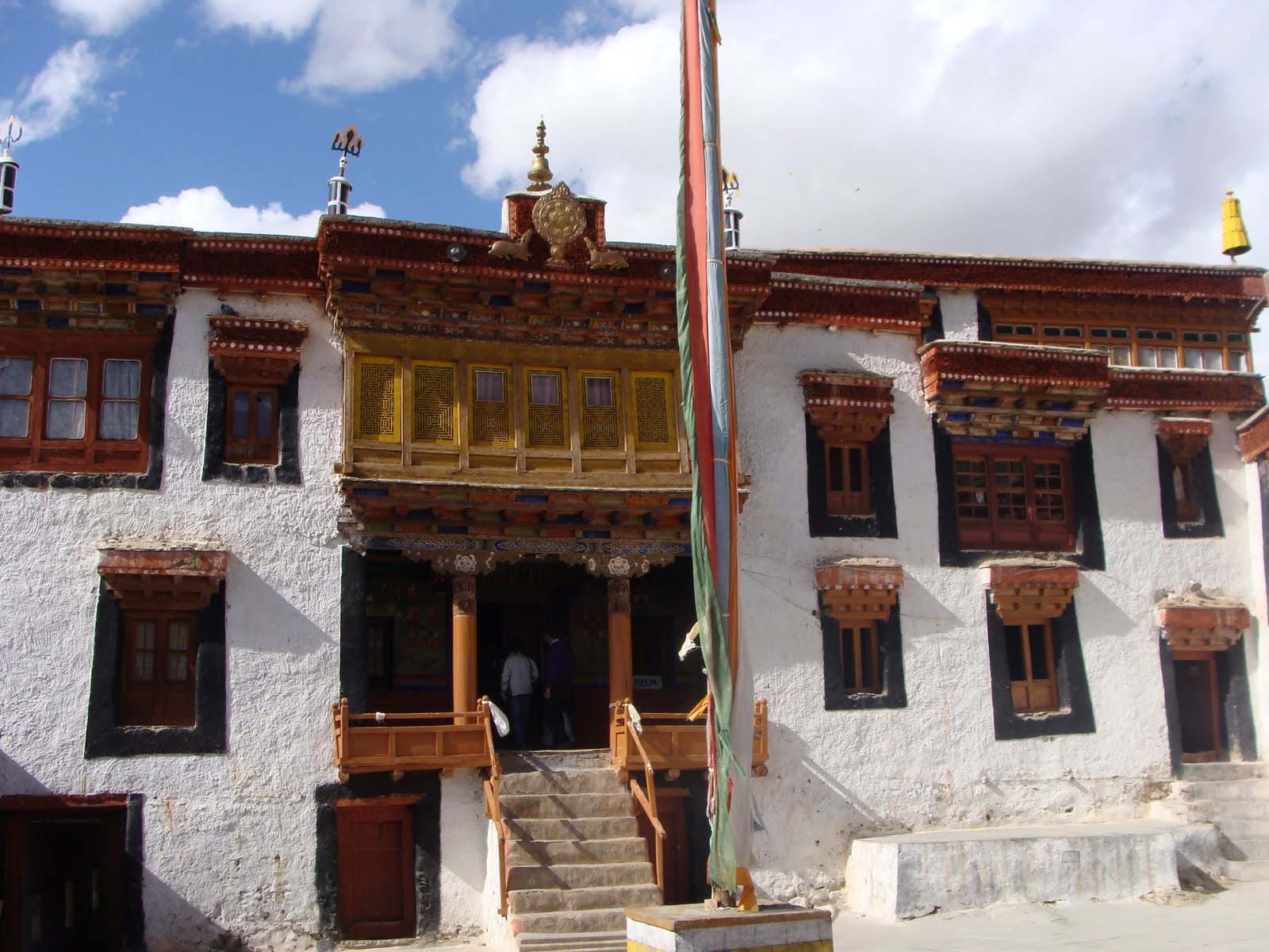
Leh-Alchi-Leh (with Gurudwara Patthar Sahib and Magnetic Hill): One can spend one day for Alchi monastery and Magnetic Hill. One has to drive on the Leh-Kargil-Srinagar higway. The route is Leh to Gurudwara Patthar Sahib to Magnetic Hill to Alchi. The “magnetic hill” is located in the vicinity of Saspol on the left side of Leh-Srinagar road across Indus river, about 50 km from Leh, at a height of 11,000 feet above sea level. The village Alchi differentiate itself from other villages of Ladakh by being so lush green. The village is famous for the existence of one of the oldest monasteries in Ladakh (a national heritage) Alchi Monastery, mainly known for its magnificent, and well-preserved 11th or 12th century wall paintings, all in an Indian style.
Magnetic hill
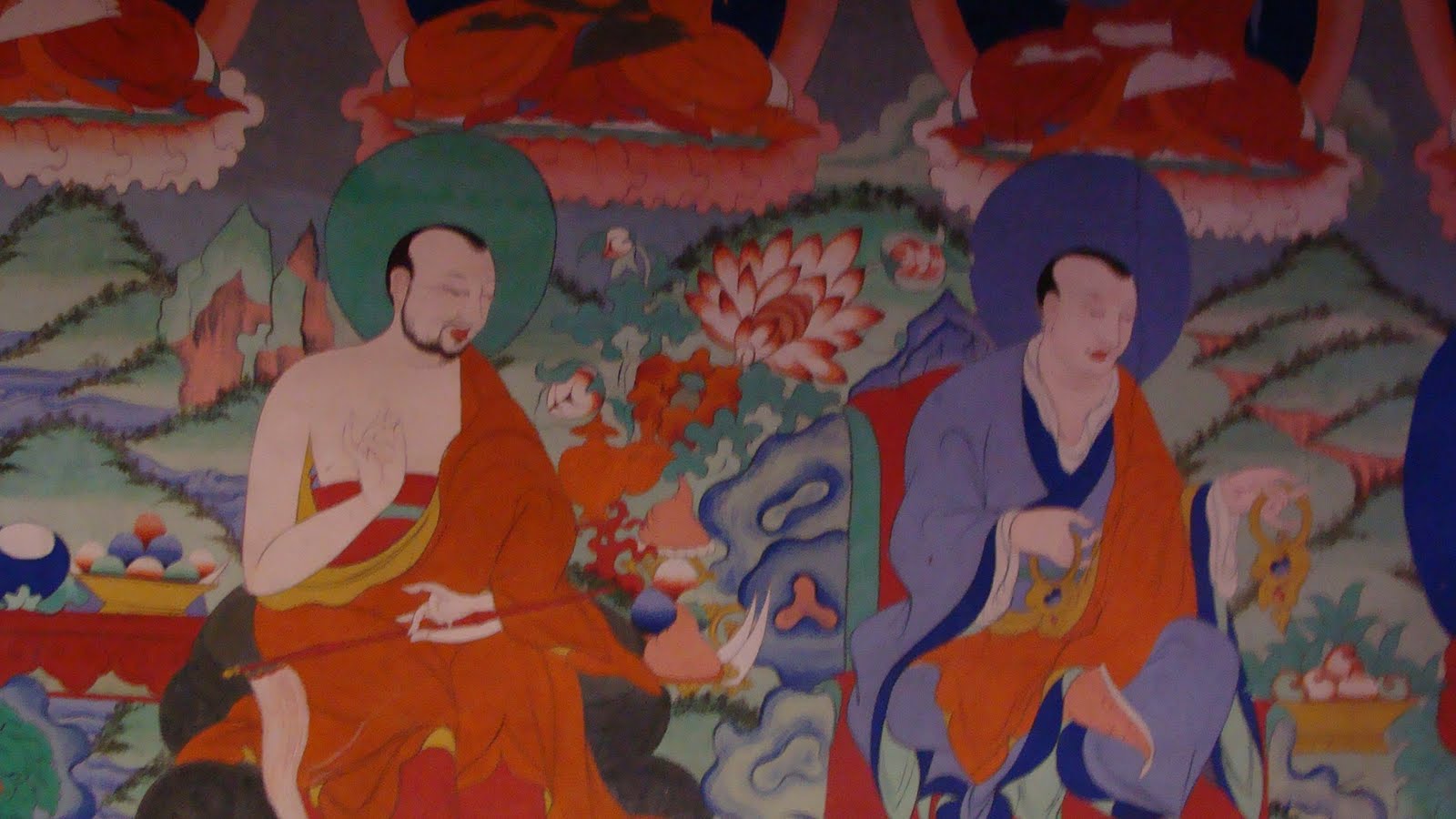
Paintings at Alchi Monestry
Alchi Monestry
§ Thiksey Gompa: This monastery is located 17km on the main highway from Leh in the direction of Manali. The present day monastery which overlooks the village below was not the original location. It was originally built at Stakmo. The present day monastery was founded by Paldan Sherab. This monastery hosts the festival of Thiksey Gustor.
Lamayuru: This is located 125km west of Leh in the direction of Kargil. It is one of the most beautifully located and built Gompas in Ladakh. There are no clear records regarding who built the Gompa but texts state that Arahat Nimagung, during his visit to the location, made offerings of grain and corn which took the shape of Swastika or Yungdrung. Besides the amazing visual aspect that makes it a must visit destination, it also plays host to the fascinating Yuru Kabgayat festival. Another major attraction of this area is the incredible landscape facing the monastery knows as Moonscape by travellers.
§ Tsomoriri (Lake): This beautiful salt water lake is located 240km from Leh. It is situated between beautiful high mountains in the Rupsho valley at an altitude of 14,000 feet. The water is clear and besides being an awe inspiring sight, it also attracts many bird species. A village by the name of Korzok is located along the south-west side of the lake. This village also houses a monastery dating back to 1851. The biggest attraction to the lake, for many tourists, are the Changpa nomads who can be seen grazing their goats and yaks in the area around.

Tso Moriri Lake